
Maps still label Japan with tidy blocks, yet the everyday word in English often swings between provinces, states, and prefectures. For today’s administration, the precise term is prefecture: forty-seven units that sit just below the national government, each with a governor, an assembly, and a capital city that organizes daily life from schools to roads.
The confusion is not random. Older provinces (kuni) left names that still flavor food, dialects, and train lines, while the modern map was rebuilt after the Meiji reforms. Below you get the full list—Japanese names, capitals, regions, population, and area—plus the small but useful difference between to, dō, fu, and ken.
Contents 5
Prefectures, not provinces: to, dō, fu, and ken
Japan’s first-level divisions are collectively called todōfuken (都道府県). Functionally they work the same way, but the four suffixes carry historical weight:
- To (都) — Tokyo Metropolis (東京都). One metropolis for the capital area.
- Dō (道) — Hokkaidō (北海道). The only “circuit” prefecture, covering Japan’s northern island as a single unit.
- Fu (府) — Osaka and Kyōto. Two urban prefectures with deep commercial and imperial history.
- Ken (県) — the remaining forty-three prefectures proper, from Aomori to Okinawa.
In English travel writing, “province” still appears, but it usually points either to a lazy translation or to the historical provinces. When you book a train, fill a form, or read population rankings, prefecture is the word that matches how the country is governed today. For how cities, wards, and towns sit under these units, see the companion guide to the division of Japan into prefectures and cities.
The eight regions that frame the map
Prefectures are the legal layer; regions are the cultural and travel layer people actually use when planning a trip. There is no single “region government,” yet the eight-way split shows up in weather maps, rail passes, and food guides:
- Hokkaidō — Hokkaidō
- Tōhoku — Aomori, Iwate, Miyagi, Akita, Yamagata, Fukushima
- Kantō — Ibaraki, Tochigi, Gunma, Saitama, Chiba, Tokyo, Kanagawa
- Chūbu — Niigata, Toyama, Ishikawa, Fukui, Yamanashi, Nagano, Gifu, Shizuoka, Aichi
- Kansai (Kinki) — Mie, Shiga, Kyōto, Osaka, Hyōgo, Nara, Wakayama
- Chūgoku — Tottori, Shimane, Okayama, Hiroshima, Yamaguchi
- Shikoku — Tokushima, Kagawa, Ehime, Kōchi
- Kyūshū (incl. Okinawa) — Fukuoka, Saga, Nagasaki, Kumamoto, Ōita, Miyazaki, Kagoshima, Okinawa
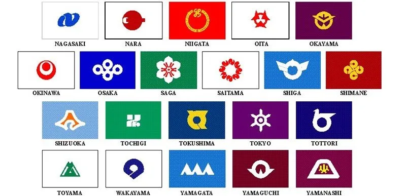
If you want the travel-oriented snapshot of climate, food, and routes by block, start with Japan’s 8 regions at a glance. Each prefecture also has its own flag and mon—handy when you spot symbols on local trains or product packaging; the gallery of Japanese prefecture flags unpacks those designs.
Full list of the 47 prefectures of Japan
The table below ranks prefectures by population (national census, 1 October 2025). Area is in square kilometers; density is people per km², rounded for readability. Capitals are the seats of prefectural government—not always the largest city in every everyday sense, but the administrative center used on official maps.
| Prefecture | Japanese | Capital | Region | Population | Area (km²) | Density |
|---|---|---|---|---|---|---|
| Tokyo | 東京都 | Shinjuku | Kantō | 14,246,219 | 2,194.03 | 6,493 |
| Kanagawa | 神奈川県 | Yokohama | Kantō | 9,193,657 | 2,416.11 | 3,805 |
| Osaka | 大阪府 | Osaka | Kansai | 8,764,578 | 1,905.32 | 4,600 |
| Aichi | 愛知県 | Nagoya | Chūbu | 7,449,403 | 5,173.07 | 1,440 |
| Saitama | 埼玉県 | Saitama | Kantō | 7,287,169 | 3,797.75 | 1,919 |
| Chiba | 千葉県 | Chiba | Kantō | 6,258,512 | 5,157.57 | 1,213 |
| Hyōgo | 兵庫県 | Kōbe | Kansai | 5,323,825 | 8,401.02 | 634 |
| Fukuoka | 福岡県 | Fukuoka | Kyūshū | 5,081,879 | 4,986.51 | 1,019 |
| Hokkaidō | 北海道 | Sapporo | Hokkaidō | 4,985,419 | 83,424.44 | 60 |
| Shizuoka | 静岡県 | Shizuoka | Chūbu | 3,468,845 | 7,777.35 | 446 |
| Ibaraki | 茨城県 | Mito | Kantō | 2,791,207 | 6,097.39 | 458 |
| Hiroshima | 広島県 | Hiroshima | Chūgoku | 2,683,399 | 8,479.65 | 316 |
| Kyōto | 京都府 | Kyōto | Kansai | 2,502,747 | 4,612.20 | 543 |
| Miyagi | 宮城県 | Sendai | Tōhoku | 2,227,240 | 7,282.29 | 306 |
| Niigata | 新潟県 | Niigata | Chūbu | 2,068,476 | 12,583.96 | 164 |
| Nagano | 長野県 | Nagano | Chūbu | 1,954,950 | 13,561.56 | 144 |
| Gifu | 岐阜県 | Gifu | Chūbu | 1,891,489 | 10,621.29 | 178 |
| Gunma | 群馬県 | Maebashi | Kantō | 1,867,582 | 6,362.28 | 294 |
| Tochigi | 栃木県 | Utsunomiya | Kantō | 1,864,833 | 6,408.09 | 291 |
| Okayama | 岡山県 | Okayama | Chūgoku | 1,808,664 | 7,114.33 | 254 |
| Fukushima | 福島県 | Fukushima | Tōhoku | 1,711,937 | 13,784.14 | 124 |
| Mie | 三重県 | Tsu | Kansai | 1,694,896 | 5,774.49 | 294 |
| Kumamoto | 熊本県 | Kumamoto | Kyūshū | 1,678,090 | 7,409.46 | 226 |
| Kagoshima | 鹿児島県 | Kagoshima | Kyūshū | 1,512,969 | 9,187.06 | 165 |
| Okinawa | 沖縄県 | Naha | Kyūshū | 1,468,220 | 2,282.59 | 643 |
| Shiga | 滋賀県 | Ōtsu | Kansai | 1,392,439 | 4,017.38 | 347 |
| Nara | 奈良県 | Nara | Kansai | 1,269,180 | 3,690.94 | 344 |
| Yamaguchi | 山口県 | Yamaguchi | Chūgoku | 1,264,006 | 6,112.54 | 207 |
| Ehime | 愛媛県 | Matsuyama | Shikoku | 1,260,088 | 5,676.19 | 222 |
| Nagasaki | 長崎県 | Nagasaki | Kyūshū | 1,232,190 | 4,130.98 | 298 |
| Aomori | 青森県 | Aomori | Tōhoku | 1,140,395 | 9,645.64 | 118 |
| Iwate | 岩手県 | Morioka | Tōhoku | 1,125,502 | 15,275.01 | 74 |
| Ishikawa | 石川県 | Kanazawa | Chūbu | 1,088,221 | 4,190.94 | 260 |
| Ōita | 大分県 | Ōita | Kyūshū | 1,076,875 | 6,340.76 | 170 |
| Miyazaki | 宮崎県 | Miyazaki | Kyūshū | 1,018,904 | 7,735.22 | 132 |
| Yamagata | 山形県 | Yamagata | Tōhoku | 993,127 | 9,323.15 | 107 |
| Toyama | 富山県 | Toyama | Chūbu | 985,675 | 4,247.58 | 232 |
| Kagawa | 香川県 | Takamatsu | Shikoku | 907,725 | 1,876.78 | 484 |
| Akita | 秋田県 | Akita | Tōhoku | 882,100 | 11,637.52 | 76 |
| Wakayama | 和歌山県 | Wakayama | Kansai | 864,262 | 4,724.65 | 183 |
| Saga | 佐賀県 | Saga | Kyūshū | 781,214 | 2,440.69 | 320 |
| Yamanashi | 山梨県 | Kōfu | Chūbu | 779,912 | 4,465.27 | 175 |
| Fukui | 福井県 | Fukui | Chūbu | 729,386 | 4,190.52 | 174 |
| Tokushima | 徳島県 | Tokushima | Shikoku | 675,489 | 4,146.75 | 163 |
| Kōchi | 高知県 | Kōchi | Shikoku | 643,437 | 7,103.63 | 91 |
| Shimane | 島根県 | Matsue | Chūgoku | 629,460 | 6,707.89 | 94 |
| Tottori | 鳥取県 | Tottori | Chūgoku | 523,732 | 3,507.14 | 149 |
A few reading notes: Tokyo leads by a wide margin and was one of the rare prefectures still gaining residents between 2020 and 2025. Tottori remains the least populous. Hokkaidō is the largest in area and among the sparsest. Okinawa is often grouped with Kyūshū on tourist maps even though its islands form a distinct cultural zone in the Ryūkyūs.
Historical provinces versus the modern grid
Before the Meiji government abolished the feudal domains in 1871 (haihan-chiken), Japan was carved into historical provinces whose borders only partly match today’s prefectures. Names such as Musashi, Yamato, or Satsuma still appear in shrine titles, brand names, and sports team monikers. That is why a single modern prefecture can host more than one “old province” memory—and why English sources sometimes blur the vocabulary.
What did not survive as a governing layer is the old province system itself. Governors, prefectural police, high schools, and major roads sit with the todōfuken. When a label says “province” next to a modern population table, treat it as wording, not as a second legal map.
How to use this list when you travel or study
For itineraries, start from the region, then pick two or three prefectures that share a rail corridor. For language study, learn the capital and the Japanese suffix together—Tokyo-to, Osaka-fu, Hokkaidō, and every other -ken—so station announcements and forms make sense. For data work, always check the census year: Japan’s total population is slowly declining, and rural prefectures feel that change faster than the Kantō corridor.
Keep this page as a reference grid: forty-seven prefectures, eight regions, four suffixes, and a living map that still wears older names with pride.


Community
Comments
0 comments
There are no published comments in this language yet.
Send comment